
Home > Maps and Charts > Early Maps
20411. Hanborough Station, 20411

![]()
Wall Art and Photo Gifts from Network Rail
20411. Hanborough Station, 20411
Network Rail - we run, look after and improve Britain's railway
Media ID 10800584
FEATURES IN THESE COLLECTIONS
> Maps and Charts
> Early Maps
> Maps and Charts
> Related Images
VISUAL DESCRIPTION
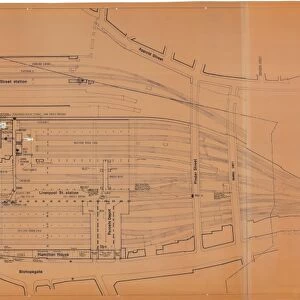
This is a vintage engineering drawing or map of the Great Western Railway (GWR) at Hanborough. The image shows a detailed schematic layout of railway tracks, including the main line and any sidings or additional infrastructure associated with the station or rail yard in that area. The design likely dates back to the late 19th or early 20th century, judging by its style and condition. It appears to be carefully drafted, with annotations for measurements and possibly signaling equipment, reflecting the precision required for railway construction and maintenance during that era.
MADE IN THE USA
Safe Shipping with 30 Day Money Back Guarantee
FREE PERSONALISATION*
We are proud to offer a range of customisation features including Personalised Captions, Color Filters and Picture Zoom Tools
SECURE PAYMENTS
We happily accept a wide range of payment options so you can pay for the things you need in the way that is most convenient for you
* Options may vary by product and licensing agreement. Zoomed Pictures can be adjusted in the Cart.
![North Staffordshire Railway - Stoke Station General Plan of Offices [N. D]](/sq/229/north-staffordshire-railway-stoke-station-14773683.jpg.webp)
![Stoke Station Improvements [1961]](/sq/229/stoke-station-improvements-1961-14773685.jpg.webp)
![Stoke-on-Trent Station Frontage - Existing Elevation [1965]](/sq/229/stoke-on-trent-station-frontage-existing-14773689.jpg.webp)
![Minor Station Improvements - Gobowen Station New Parcels Office [1967]](/sq/229/minor-station-improvements-gobowen-station-new-11952624.jpg.webp)
![L & N. W. R Smethwick - Proposed Station Buildings and Station Masters House [N. D]](/sq/229/l-n-w-r-smethwick-proposed-station-13266123.jpg.webp)
![G. W. R Ebbw Vale New Station Buildings [1923]](/sq/229/g-w-r-ebbw-vale-new-station-buildings-1923-11990233.jpg.webp)
![G. W. R Gobowen - Reconstruction of Footbridge at 189m 67chs [1898]](/sq/229/g-w-r-gobowen-reconstruction-footbridge-189m-11952620.jpg.webp)
![Northe Eastern Railway - Renewal of Selby Swing Bridge [1888]](/sq/229/northe-eastern-railway-renewal-selby-swing-11952422.jpg.webp)
![Poole & Bournmouth Railway - Parkstone and Bournemouth [c1898]](/sq/229/poole-bournmouth-railway-parkstone-11883779.jpg.webp)
![GWR Cirencester Station - Survey [N. D]](/sq/229/gwr-cirencester-station-survey-n-d-11490054.jpg.webp)